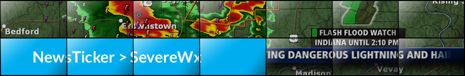
NewsTicker SevereWx
The industry's most advanced severe weather notification display
Severe weather is one of those rare opportunities to truly
differentiate yourself in your market and prove you are a
leader. So why use an alerting display that looks just like
your competitor?
NewsTicker SevereWx puts you in full control of design and
functionality. You aren't forced to use a standard look,
or a design tool with limited options. You get to create
displays from the bottom up, using the most sophisticated
design and automation tools available today.
Take charge and lead the market in severe weather notification
while putting your brand front and center with NewsTicker SevereWx.
Your brand, your design
Break from the "one size fits all" model with different looks depending on the types of active conditions. Display long-fuse events in a more compact manner than short-fuse events where time is of the essence. And, most importantly, create a design that fits your identity to reinforce your brand.
Powerful customizations
Using NewsTicker's web-based interface, your meteorologists have unparalleled control over how the system will react to each condition, including what information it should display and how frequently. During an event, your mets can easily add information to crawls about current observations to maintain FCC compliance.
Deliver fast to air, web and mobile
The instant a condition activates, it is ready for air. With our powerful automation controls, you can manage what goes to air automatically and what should be displayed manually. And, exporting to your website and mobile provider is automatic, fast and tailored to your look.
Top Features
Complete Custom Design
Reinforce your brand when it matters most. Start with a blank canvas and determine all of the visual elements and how they function. Create multiple looks to give yourself options based on conditions and progamming.
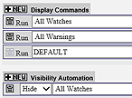
Automation In Your Control
When big storms hit, stop babysitting your alert system and use NewsTicker's advance automation controls to prescribe what airs, what doesn't, and how often, editable any time and customized by playlist.
Optimized for Duopolies
NewsTicker SevereWx allows you to manage your events centrally, through one interface, but air separately branded and designed displays on each of the channels you program. You don't need to compromise with one look for all, or deal with managing multiple instances of the same software across each station.
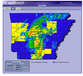
Reliable, Redundant Data
Severe weather data is received directly from the National Weather Service via C-Band satellite and direct fiber to the NWS for redundancy, and can be combined with a station's local satellite feed.
Other Features
Design Without Restriction
SevereWx uses the same templating system as NewsTicker, allowing you to include animation, clip play, custom locator maps, your own font, and timeline-based animation.
RADAR Integration
RADAR can be integrated using near real-time sequenced images incorporated into your design, or as a live DVE input.
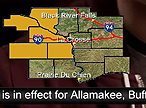
Storm-Based Warnings
NWS storm-based warning polygons can be used in place of highlighting an entire county or zone, if desired.
Dual-Language Support
SevereWx includes native dual-language support for bugs and custom crawl text. The English version can be sent to one display, the Spanish to another, or have the Spanish follow English. All of it is managed through one interface for efficiency.
Audio Sounders
Multiple audio files can be loaded and played, as prescribed, ducking program audio. You decide the audio that gets played, the channels they play in, and the condition that triggers them.
Dynamic Legend
Using advanced functionality built into NewsTicker, your severe weather bug can display a dynamic legend that cycles through all active conditions in a predictable size without continually increasing the footprint of the bug.
Integrate With All of NewsTicker
SevereWx is fully integrated with all other NewsTicker modules for continuous on-air displaying without stopping and starting multiple applications. And, your severe weather look can change based on other active conditions, such as school closings or being in news.
Selected FreedomHD Video Examples

WXOW/WQOW, La Crosse, WI (Quincy)
This duopoly uses one NewsTicker system to control two differently branded graphical looks. They employ a mini-crawl to take up less space, and combine a RADAR loop when appropriate.

WPXI, Pittsburgh (Cox)
WPXI uses a map with a cycling dynamic legend and RADAR. The crawl appears automatically based on their preferences. The overall design matches the style of their news graphics.

WAVY, Norfolk, VA (Lin)
Showing the power of integration, WAVY uses the FreedomHD to display severe weather and closings simultaneously. The name of the active county sizes itself dynamically based on length.

WJRT, Flint, MI (Gray)
This station uses a low-profile design along the top of the screen to be less obtrusive during programming. A crawl appears periodically, and instantly when new conditions are issued.
More Information
To learn more about SevereWx, including a product
demonstration and proposal, contact Newsroom Solutions
sales:
sales@newsroomsolutions.com
+1 (704) 665-5300 x1
Client Support
NewsTicker SevereWx is backed by our U.S.-based Client
Support Center. Whether you need assistance with your
displays, additional training, or have a day-of
issue, the Center is here to solve your problems quickly.
Learn more...
Selected Clients
NewsTicker SevereWx is the most advanced and customizable severe weather alerting system in America. Clients include stations from three of the four major network O&Os, Cox, Gannett, Journal, Meredith, Nexstar, Quincy, Raycom, Scripps, Sinclair, Tribune, and more.
NewsTicker is installed in 74 of the 75 largest television markets and can be seen daily in more than 90-million homes.